The Rocks Remain
Victoria Beach, Lake Winnipeg, 2014

This section of shore has been armoured with cobbles and boulders in an attempt to reduce erosion. But where is the beach?
Along Lake Winnipeg in July it felt like business as usual. At Victoria Beach we rode our bikes down narrow gravel lanes through swarms of dragonflies and clouds of midges, basking in the perfect warm air and golden sunlight. The shop, bakery, tennis courts, and playground were busy. But what about the beach? If you listened to the residents, beyond the usual small talk, this question remained: what about the beach? And what about the scarps behind it?
Manitoba’s lakes have been having issues of one sort or another for decades. Most summers Lake Winnipeg has trouble with algal blooms as a result of increased nutrient flow from farms and cities, though the extent of this problem varies from year to year. In 2011 the shores of Lake Manitoba were devastated by high lake levels, after Assiniboine River flooding resulted in heavy use of the Portage Diversion channel. This year water has again been very high on Lake Manitoba and Lake Winnipeg, after heavy precipitation in the late spring and early summer.
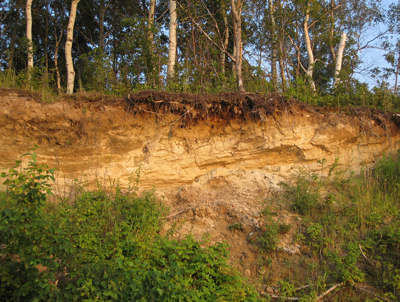
The freshly cut scarp reveals stratified sand, soil, and roots.
On Lake Winnipeg, cottagers always reckon that their shorelines suffer from increased erosion because Manitoba Hydro keeps water levels high, the better to power dams on the Nelson River system. This could certainly be a cause, particularly when this high lake level is augmented by unusual rainfalls. But there is another factor, a geological one, which most people ignore because of its subtlety and complexity.
The land of Manitoba has been slowly rising for the past 10,000 years or so, as the crust rebounds from being pressed down by glacial ice that was hundreds or thousands of metres thick at the height of the last ice age. The ice melted away from south to north, so the southern part of the province is now closer to equilibrium and is rising slowly. In the north, the rebound is still more rapid (even farther north, near Churchill, the rate of rise is close to a metre per century!).
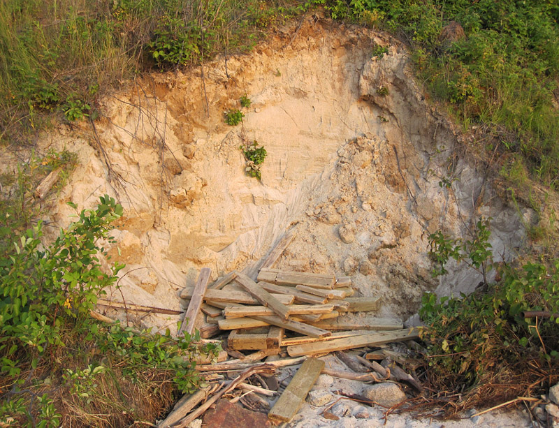
I suspect that the wood at the base of this slope is the remnant of someone’s stairs to the beach.
Postglacial rebound may seem like an interesting if remote phenomenon, but its effect “on the ground” is this: Lake Winnipeg’s outflow is at the northern end of the lake, and since this is the part that is rising more rapidly, the basin is gently tilting southward (imagine what happens as you tip a dish full of water). The lake is gradually moving across the flat lands at its southern end, reclaiming the marshes of the Red River Delta and the beachfronts of Ponemah and Matlock. Given enough time (before this land is again subject to large-scale glaciation), the lake will surely arrive where downtown Winnipeg stands today.
But this will take centuries or millennia. Meanwhile, whenever there is high water the lake will take advantage of it, moving just a bit farther southward and chewing away at the wonderful shorelines of Grand Beach and Victoria Beach. These shores are soft, being composed largely of sediment left behind by that glacial ice. The waves readily remove sand and gravel from the beaches and scarps, leaving behind only the larger boulders, and the shoreline continues to retreat. From a human standpoint this seems unfair and a great shame, but we can only hope to slow down nature. It will always win in the end.


The scarp may be moving back, but the gneiss and granite boulders aren’t going anywhere.


A lot of detail on the geology of the Lake Winnipeg basin was published in: Lake Winnipeg Project: cruise report and scientific results; Todd, B J (ed.); Lewis, C F M (ed.); Thorleifson, L H (ed.); Nielsen, E (ed.). Geological Survey of Canada, Open File 3113, 1996, ; 656 pages, doi:10.4095/207501
© Graham Young, 2014


I recently learned just enough about glacial rebound to understand why some rivers in Ohio flow north rather than south, the way most of them do. It’s fun to know that glacial rebound is still happening, though I’m sorry you are losing that beach. Thanks for another interesting lesson.
Linda, many thanks as always for your comment (sorry it has taken me a while to reply; I am in and out of town at the moment).
Hi. Nice post. Erosion is such a difficult issue, one where nature and humans don’t quite meet. I know a couple of places in NB/NS where property owners have used discarded gravestones to ‘armour’ the shoreline. Jane
Jane, many thanks. Those discarded gravestones as shoreline armour could make for some wonderfully strange images!
Hi again Graham! Our family had a cottage at Victoria Beach during the 1960s.on 8th Ave. Embankment erosion was an ongoing process then as well. The Regional Municipality of VB were constantly trying to “fix” these onslaughts of nature by dumping big boulders of granite down to the shoreline. More than once, I can remember seeing large concrete and steel pipe steps that led down from the embankments, turned on their sides, or completely flipped over, due to being undermined by the wash of the summer storms that occasionally happened. These structures must have weighed as much as a bus or more, yet they were rendered almost to wreckage by the waves.
These events would be as long ago as 50 years now, and the process never sleeps.
My favorite memory, (besides the bakery, the pier, the movie theatre/clubhouse and the Moonlight Inn, is of being able to walk to Elk Island via the sand bar that sometimes formed at the top end of what we called Sandy beach.
Many thanks again!
Steve, thanks for your interesting comment.